Redeveloping the banks of the Haute Deûle


Icons target

Status

ongoing

Icons use case study city info

City

European Metropolis of Lille

Icons use case study main actors

Main actors

City Government

Icons use case study project area

Project area

Neighborhood or district

Icons use case study duration

Duration

Ongoing since 2003

Transforming an industrial landscape into a sustainable green eco-district.

The City of Lille made the river Deûle the focus in the redevelopment of an old 25-hectare industrial site, recognising its social and environmental benefits as well as its key role with respect to climate change adaptation.

The new district ensures social diversity with a balance between properties for sale and for rent at market prices, affordable housing, and social housing. Additionally, the Eura Technologies centre, dedicated to Information and Communication Technologies in the metropolitan area, has been established on the site of the former Le Blan Lafont cotton and linen factory.

This case study was contributed from the Covenant of Mayors - Europe.

Case study on The banks of the Haute Deûle, an eco-district along the waterway


Sustainable Development Goals

Ensure availability and sustainable management of water and sanitation for all
Make cities and human settlements inclusive, safe, resilient and sustainable
Take urgent action to combat climate change and its impacts
City
European Metropolis of Lille, France

Size and population development
The European Metropolis of Lille (MEL) brings together 90 municipalities with a population of 1, 154,103 recorded in 2014. it is the fifth largest urban area in France after Paris, Lyon, Marseille and Toulouse.

Population composition
43.5% of the population are under 30 (source KPMG 2016). The population increased at a growth rate of 0.4% between 2010 - 2014. 36% of people in the European Metropolis of Lille live as a single-person household.

Main functions
The European Metropolis of Lille is an intercommunal structure, centered on the city of Lille. It is located in the northern department, in the Hauts-de-France region of northern France, bordering the Flemish and Walloon regions of Belgium and covers the part of the Lille metropolitan area that lies in France.

Main industries / business
Located at the crossroads of North-West Europe, European Metropolis of Lille sits at the centre of the wealthiest consumer pool in Europe, gathering 80 million citizens and a GDP of 1,500 €Billionn within a 300 kms radius. The metropolis’ proximity to the key decision-making centres of the European Union (London, Paris, Amsterdam, Brussels, Luxembourg), combined with transport infrastructure including 2 High Speed Train stations (25 million passengers annually) and its vibrant economy make the European Metropolis of Lille a preferred location for foreign investors. Lille European Metropolis ranks in the top 3 regions in France for foreign direct investments. Historically a major trade hub, Lille European Metropolis has the highest concentration rate of exporting companies amongst French metropolises.

Sources for city budget
Adopted on February 10, 2017, the total budget of MEL is € 1,625 million. Despite the decline in state allocations, it is characterized by a priority for investment, the pursuit of rationalized management of operating expenses, fiscal stability for metropolitan areas and businesses

Political structure
The Metropolis of Lille is a public institution of intercommunal cooperation established by the law of December 31, 1966 in order to remedy the disadvantages resulting from the fragmentation of municipalities in large cities. On 1 January 2015, Lille Métropole became the European Metropolis of Lille as provided by the law of modernization of territorial public action and affirmation of metropolises called MAPAM law, adopted on January 27, 2014. The 184 elected members of the MEL were appointed after the vote of the Metropolis Council of December 15, 2016. They come from the 90 municipalities that make up the Lille Metropolitan Municipality. All municipalities of the MEL are represented on the council according to the number of inhabitants (1 elected for the smallest municipalities and up to 33 seats for the most populated). The President of the European Metropolis of Lille is in charge of the implementation of the metropolitan policy.

Administrative structure
The MEL wants to involve citizens in decisions and develops participation through public meetings, participatory workshops, preliminary consultations, public inquiries, major debates, etc. It also has consultative bodies such as the Development Council that allow citizens to express themselves better.

The banks of the Haute Deûle constitute a specific territory, defined both by its industrial history, with the Le Blan Lafont factory, and by the presence of water. Extending across the municipalities of Lille and Lomme, this territory covers an area of 25 hectares, on the two sides of the Deûle canal.

Even though the canal crossed the district, it essentially only had an industrial role. In fact, the presence of water was not very noticeable in the surrounding neighbourhoods. The territory surrounding the city is flood-prone due to the topography of the area and the presence of groundwater close to the surface. Surface water was of poor quality, presenting eutrophication of water courses, particularly for the Deûle.

The key objective of the project is to rehabilitate the old industrial area and transform it into an appealing and sustainable place to live while simultaneously enhancing the industrial heritage.

The redevelopment of the site started at the end of 2003 with the creation of a Joint Development Zone.

Mobility, low carbon buildings and circular economy

The desire to make the neighbourhood resilient to the effects of climate change and respectful of the environment was linked to the minimization of energy consumption.

The district was designed to limit the use of the car, particularly through the construction of carparks. Less carbon intensive modes of transport are encouraged due to the provision of space for pedestrians and bicycle - twice as much of the neighbourhood’s surface is dedicated to pedestrians and bicycles than to cars. The metro, free bike service, and a car sharing point are easily accessible, especially for people with reduced mobility.

The buildings have been designed with high energy performance requirements, making the choice of energy sources reversible and favouring the use of renewable energies. The architectural choices that were made invite developers to use a minimum amount of wood in the construction of housing to support the development of a sector still little developed in the region.

In addition, 80% of the waste is upgraded or recycled at the neighbourhood level.

Public spaces rich in biodiversity

Although the average density of the neighbourhood is higher than in surrounding areas, the redevelopment of the district designated a large part of the area to public spaces which make up almost half the surface of the joint development zone. These public spaces involve the realisation of a green network including the planting of 1,000 trees, half of which are in the public space (10 hectares) and the creation of 25% green spaces (6.25 hectares) half of which are in the public space.

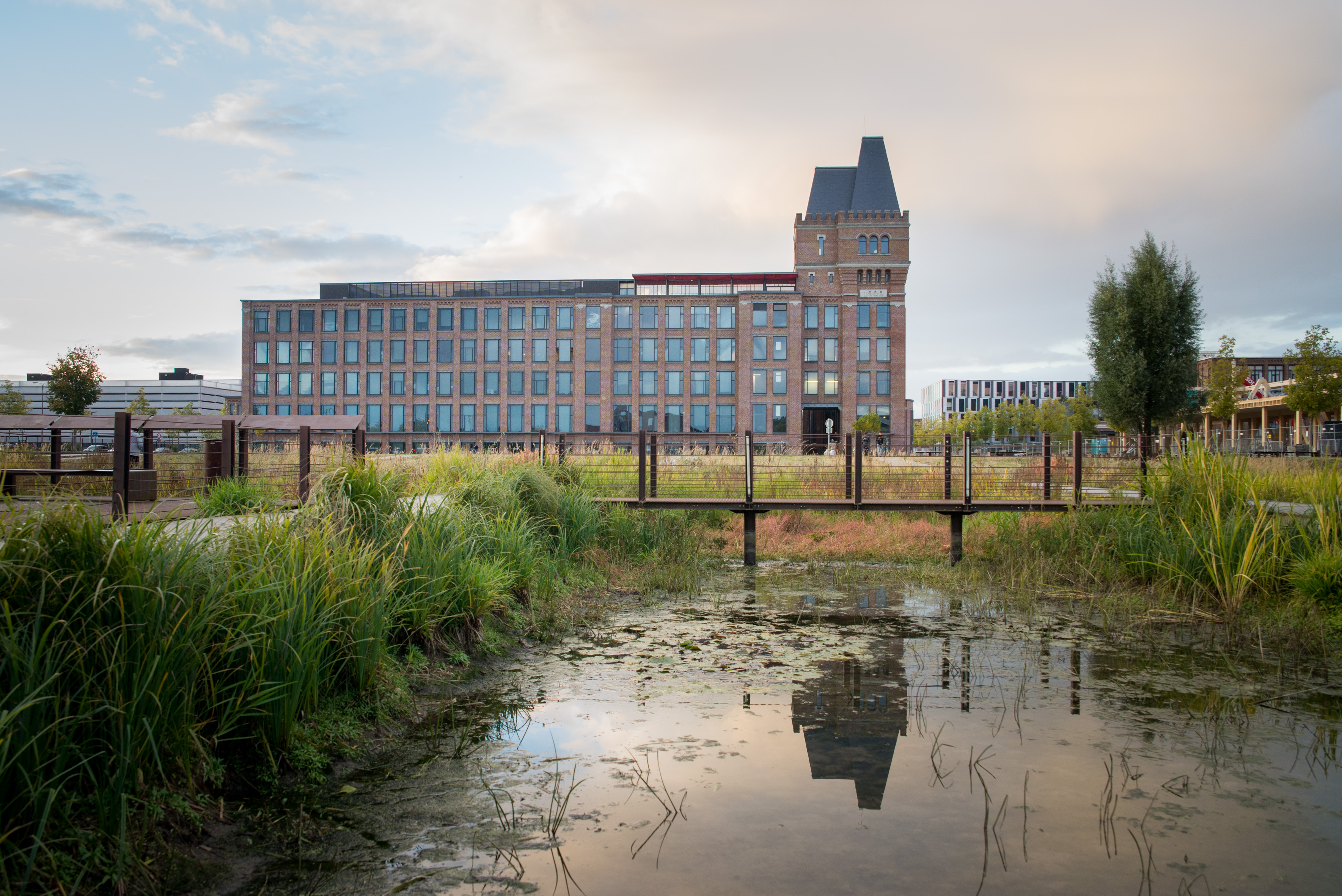
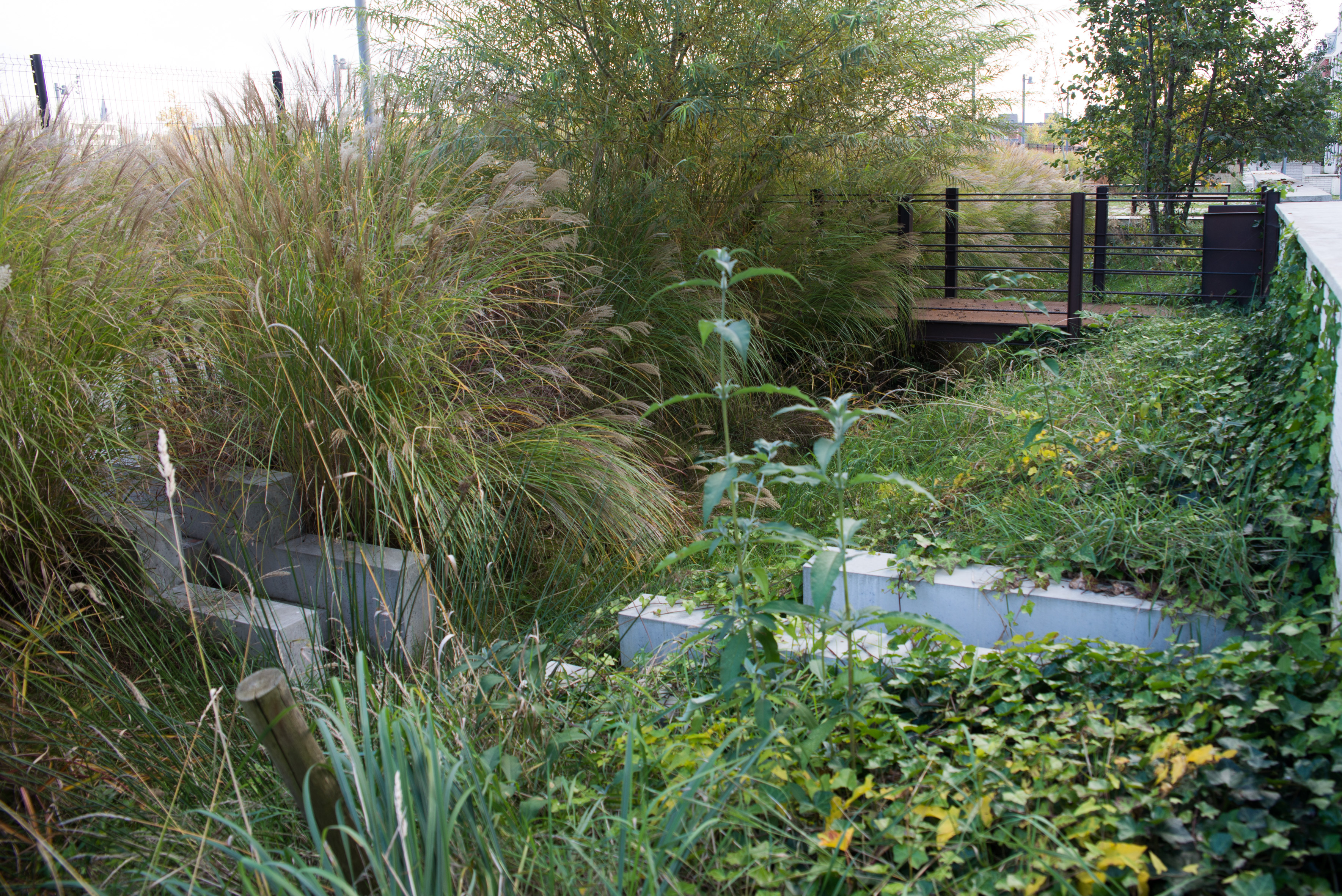
This green network creates a pleasant landscape frame as well as a biodiversity shelter and space for rainwater infiltration, and it attenuates the urban heat island effect. The choice of local species, used to living close to water, was favoured, and particular care was taken in the planting of trees using a spemanagement policy. Green spaces are also places for conviviality and ‘breathing spaces’, providing a better quality of life in an area marked by the high density of buildings.

A water cycle both regulated and respectful of the environment

It was decided to give emphasis to the presence of water by directing it to the heart of the neighbourhood, close to housing and offices.

The development prescriptions initially regarded the regulation of discharges into the natural environment:

  • Set-up of a water basins and watersheds system bringing water downstream for regulated discharge into the canal;
  • Integration of the watershed system with public spaces thanks to swales, canals integrated alongside roads, and water gardens;
  • Qualitative treatment of water through sedimentation in the canals and through phytoremediation in the water garden;
  • Rainwater management entirely based on gravity, due to refined altimetric management applied to the development of public spaces (rooftops with vegetation, storage tanks);
  • Prohibition of irrigation with drinking water (public or private), collection and storage of rainwater through rooftops;
  • Location of buildings decided based on the soil composition, in order to respect the balance of groundwaters as much as possible. In order to mitigate the risk of floods, the city has also decided to cap soil-sealing at 80%. Some management prescriptions have been formulated regarding the treatment of external mineral surfaces with maximum permeability in joints or materials. The technical specifications have also imposed a minimum ratio of open ground of 20% (applied to the 20% permeable soil), with local variation

The project now counts 38 hectares, including the 25 hectares of the first phase, with a short-term transformation capacity which invites to continue the development of the existing zone and use its full potential. The project ultimately includes the extension of the network of soft mobility corridors, and the creation of ‘Turtle park’, a vast green and recreational area.

The lead agency for the project is the City of Lille in partnership with the City of Lomme.  The total budget for the project is 75million euro. Finance has been provided by the Lille European Metropolis, the City of Lille and the City of Lomme, and grants from ERDF, the National Agency for Urban Renovation, and ECOCITE.

The project has received many awards including:

  • The Urban Development Award 2010 for its social and urban diversity;
  • The 2009 Eco-District award for its landscape and environmental quality;
  • The Eco-district label of the French Ministry of Equality of territories and housing in 2013.

The 152,000 m2 of the first phase of development are now being sold, i.e. 860 housing units delivered or being finalised, and 80,000m2 of tertiary surface.

A number of environmental and climatic issues related to water management had to be addressed.

Given the potential of the urban project, it has been decided to continue its development.

On the Map

Map placeholder

Want to know more about this project?

Covenant of Mayors – Europe
Brussels Capital Region, Belgium

Covenant of Mayors – Europe

Institution | EU-wide movement for cities and regions on climate and energy

Photo gallery