 - © © IVP
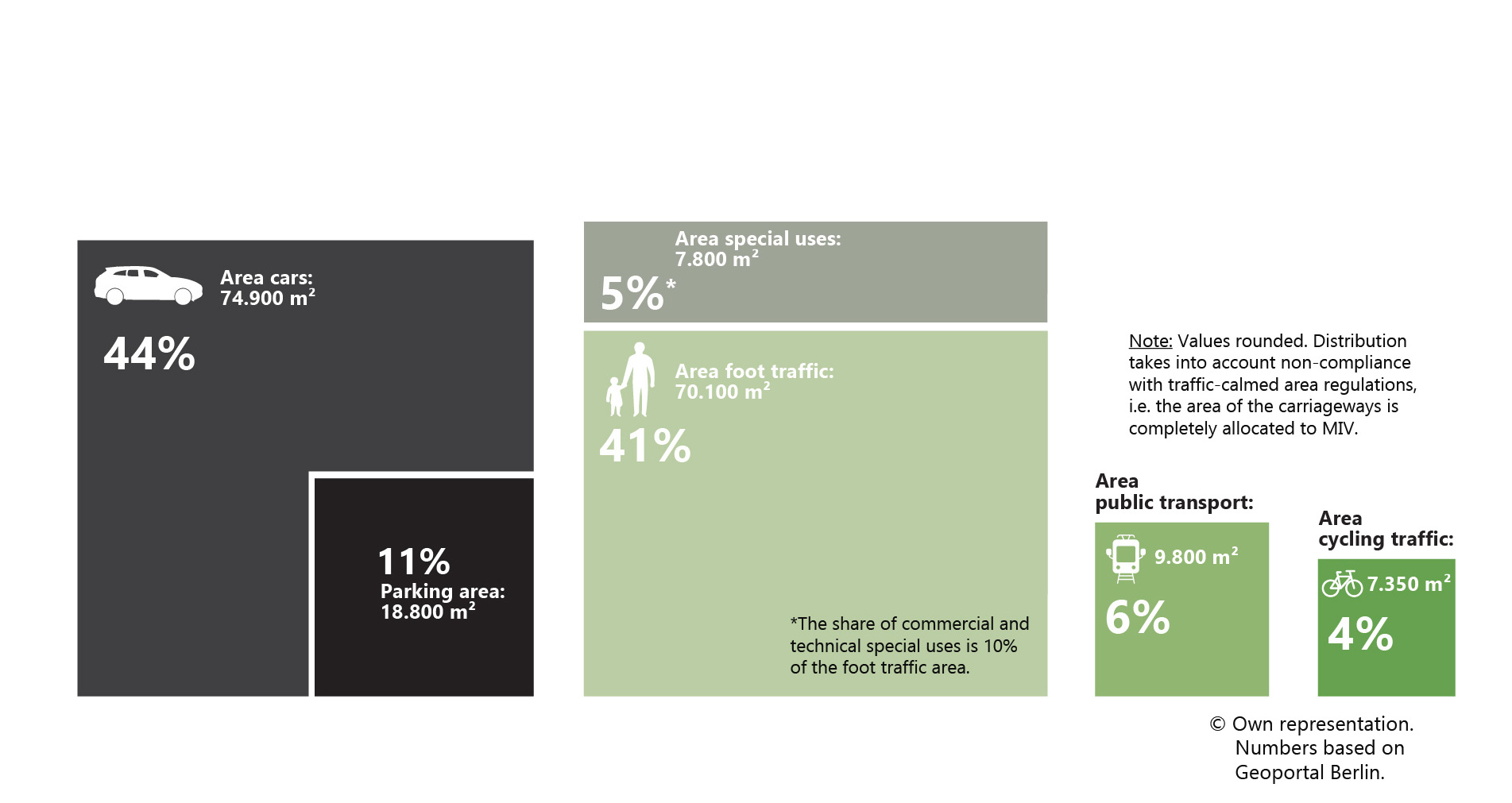 - © © IVP
 - © © IVP
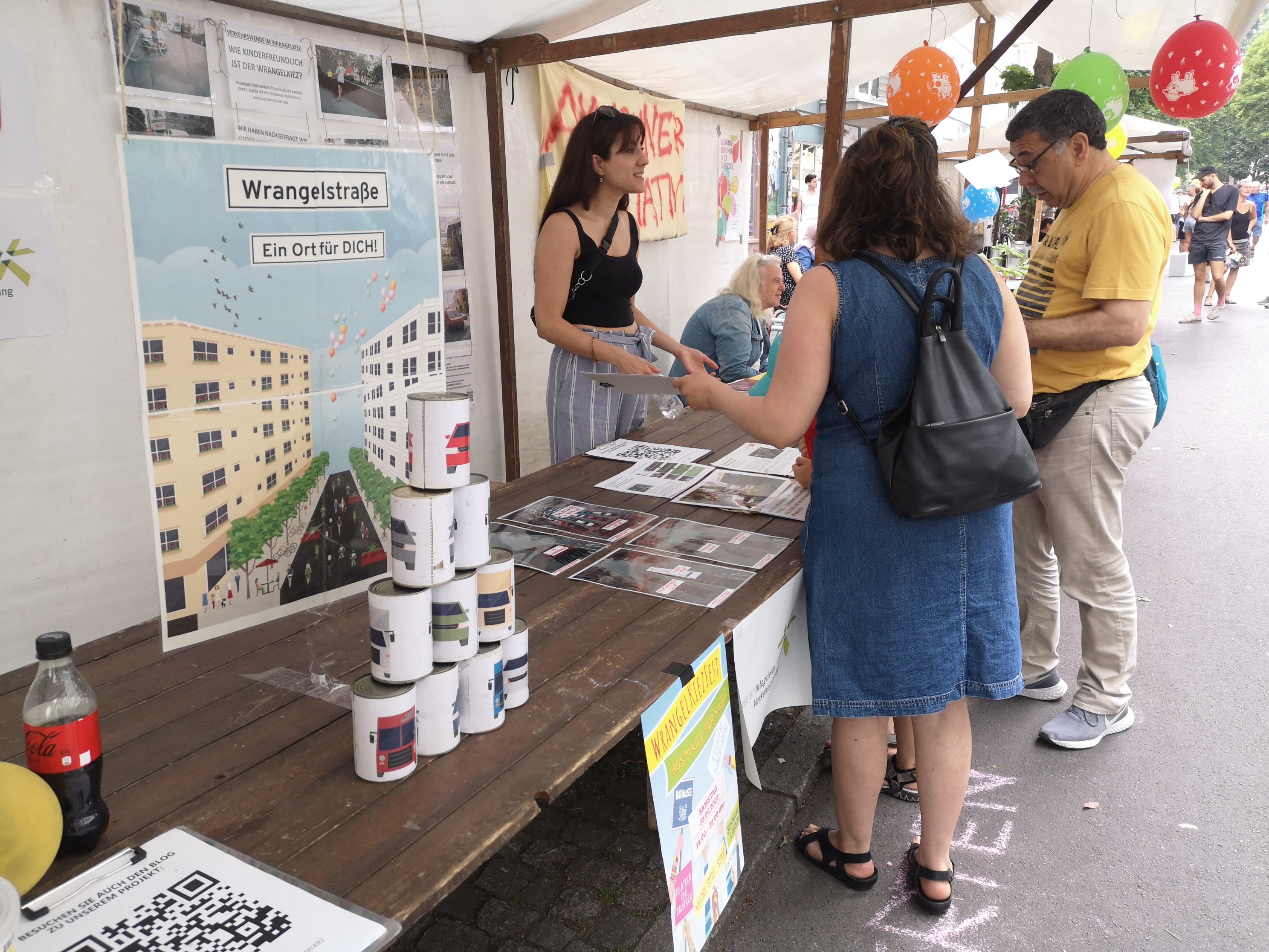 - © © IVP
 - © © IVP
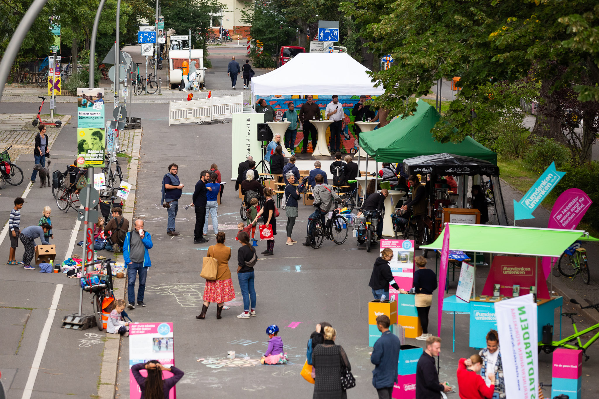 - © © Florian Reimann
Item 1 of 6
Status
completed
100%
City
Berlin
Main actors
City Government, National Government, Community / Citizen Group, Research Institutes / Universities
Project area
Neighborhood or district
Duration
2020 - 2023
The project supports the Berlin-Kreuzberg district authority in their plans to adapt the public space of the dense and heterogeneous Wrangelkiez to the requirements of sustainable mobility and climate-friendly design. The focus is on researching and optimizing the participatory and cooperative planning process. The results will be processed and published in the form of a practical guide for municipal traffic planning.
At the neighborhood level, non-motorized traffic (pedestrian and bicycle traffic) in particular makes a significant contribution to the transition to more sustainable mobility. Zero-emission, human-scale, muscle-based mobility at low speeds has very positive environmental, social, and economic impacts on urban neighborhoods. In order to promote this idea, it is important to involve residents, local shopkeepers and other stakeholders at different stages of the project. The project focuses on dealing with conflicts and barriers throughout the process. It tests new methods of participation and qualitative data collection and develops new planning and analysis tools.
The project is being processed by the Department of Integrated Transport Planning at the Technical University of Berlin (TU Berlin). The Federal Ministry for Digital and Transport (BMDV) funds the project.
City
Berlin, Germany
Size and population development
In 2019, the municipality of Berlin had a population of 3,669,491 inhabitants, making it the most populous city in the European Union (EU). The larger metropolitan area has about 5 million inhabitants.
Population composition
According to estimations, about one third of Berlin’s population was foreign born or has a migratory background. These inhabitants originate from other parts of the EU—such as Poland, Italy or Bulgaria—as well as from countries outside of the EU, such as Syria, Vietnam or the United States of America. The largest non-native population comes from Turkey: In 2019, more than 107,000 Turkish nationals were registered as inhabitants of Berlin.
Main functions
Berlin is the capital and largest city of Germany. As a city-state it is also one of the country’s 16 Länder, as the federal states are called in Germany. Situated approximately 112 miles (180 km) south of the Baltic Sea, the city lies in the wide glacial valley of the Spree River, which runs through Berlin’s centre. The city extends over an area of 891.7 square kilometres and stands at an average altitude of 34 meters above sea level. After the reunification of Germany and East and West Berlin in 1990, the unified Berlin was re-established as the country’s capital (replacing Bonn, the former capital of West Germany). In 1999, large parts of the Federal Government and the German Bundestag finally moved back to Berlin. Berlin is a city of great historical significance, which becomes evident considering the amount of historical landmarks that visualize the city’s history. Some of the most important landmarks include the Brandenburg Gate (built in 1793), the Reichstag Building (which dates to 1884), remnants of the Berlin Wall (taken down on the 9th of November 1989) or the Holocaust memorial (inaugurated in 2003). Berlin is also a famous cultural hub, known for its world-class museums, theatres, operas and concert halls as well as its vibrant club scene and street art. Finally, the Brain City Berlin is a leading location for science and research. It is home to a number of prestigious universities such as the Freie Universität Berlin, the Humboldt Universität zu Berlin and the Technische Universität Berlin, with more than 35,000 students each as well as renowned research institutions and think tanks.
Main industries / business
As the fourth largest economy of the world, Germany has a wide array of prestigious industries. Berlin is home to a diverse mix of economic activities: state-owned enterprises, creative industries, automotive manufacturers, (digital) media corporations, high-tech and telecommunication companies as well as multiple digital pioneers that flourish in the city’s vibrant start-up scene. Tourism is constantly growing and brings about 14 million visitors (2019) to the city every year.
Sources for city budget
Berlin draws its budget for public expenditure largely from taxes, federal transfers, fees, fines and operating revenues. It is spent not only to provide high quality public services, but also to boost the city’s private sector, civil society engagement and cultural life.
Political structure
The city-state Berlin is governed by the Berlin Senate, which is comprised of 10 senators, and the Governing Mayor. As the capital of Germany, Berlin hosts the Bundesregierung (federal government), the Bundestag (federal parliament) and the Bundesrat (the parliamentary chamber of the 16 Länder). Each of the 16 Länder has a representation in Berlin. On many political issues, the Länder have co-legislative powers vis-à-vis the Federal government. Moreover, Berlin hosts embassies from more than 120 countries from around the world.
Administrative structure
Berlin is administrated by the Senate and its 12 districts or boroughs (Bezirke). The Senate is the city’s central administration, in charge of city planning, public policy, and the regulation of public and private spheres. The district administrations have some decentralized public functions, with reasonable differences between the various localities.
Website
http://www.berlin.de
Wrangelkiez is a neighbourhood in the Kreuzberg district of Berlin with a population of 10,600. Wrangelkiez has an above-average proportion of younger residents (63.7% of residents aged under 45) and residents with migration background (52.4%).
In this research project, a local mobility concept for the high-density urban neighborhood Wrangelkiez in Berlin-Kreuzberg will be developed and implemented in a participatory manner. The specific requirements of civil society on the one hand and municipal politics and planning on the other hand will be included. The focus is on the mobility-friendly transformation of the district as a participatory process.
The traffic situation in the Wrangelkiez shows a multitude of problems. The requirements for safe, environmentally friendly and city-compatible mobility – as e.g. according to the Berlin Mobility Act – are not met. This should change in the coming years - in cooperation with the people in the neighborhood, the district office of Friedrichshain-Kreuzberg and the TU Berlin!
The chosen study area in Berlin-Kreuzberg has a particularly active civil society, which has already developed its own concepts for the low-car transformation of the neighborhood (see "Wrangelkiez Autofrei!" - LINK). Municipal politics are also open to a redesign of the urban space in favour of cycling and walking, which is why this project offers the rare opportunity to bring together the central actors for local mobility under scientific supervision. On the other hand, people oppose the project and the goals for a sustainable transformation of the neighborhood.
Therefore, residents and various stakeholders should be involved in decision-making, testing (temporary) solutions in real life and collecting data on specific requirements and needs.
The project implementation consists of different phases. First, data was collected, framework conditions and constellations of actors were analysed, a mobility concept was developed and a new participation method was tested. Subsequently, conflicts and hurdles in the perception and attitude of the residents were identified and information on how to address and deal with them was collected. In the last phase of the project, recommendations for the optimization of participatory planning processes in the mobility transition will be derived from the collected findings and published in a guide.
Mobility surveys with marginalized groups (2020-2021)
To learn more about the needs for mobility transformation of people that are usually not included in participation in transport planning, e.g. children and Turkish women, qualitative methods like Photo-Voice, Mental Mapping and group interviews were applied in addition to a representative survey.
On-site pop-up participation (2021)
A new method of participation was tested on the Görlitzer Ufer, one of the streets in the neighborhood. In order to find out the opinions and preferences of users regarding the redesign of the street space between Görlitzer Park and the Landwehr Canal, motorized traffic was excluded from the street and a wide range of participatory measures were offered. The street was opened to enable people to use public space in a new way and to experience the advantages of a car-free zone. In addition, numerous campaigns and information offers took place to get residents and passers-by talking about the redesign.
Local mobility concept (2022)
The local mobility concept examines the framework conditions of a mobility transition and relates them to each other on the structural levels of space, settlement, social issues, mobility, traffic and environment. The result is a comprehensive and detailed view of the neighborhood that goes beyond a traffic-related consideration. By integrating a wide variety of aspects, the concept identifies interactions and possible conflicting goals in order to derive tailor-made needs for action.
Environmental and spatial justice analysis (2021-2022)
As a basis for a sustainable urban and traffic development, that offers more space for pedestrians, cyclists and livability, an inventory and evaluation of the allocation of public space was necessary. Therefore, a new methodology was developed and applied to prove the unfair street-space allocation with regard to sustainability objectives and the need for redistribution.
Stakeholder analysis and programmatic framework paper (2021-2022)
The positions and needs of various stakeholders as well as the findings from the local mobility concept formed the basis for a programmatic framework paper. The paper summarizes a common understanding of different problems and derives corresponding target agreements as a framework for the further course of the project and the science-practice cooperation.
Conflict and process evaluation (2022-2023)
Based on an evaluation of various statements in surveys and participation results, typical lines and areas of conflict were identified. By classifying the course of the process and interpreting various planning-strategic decisions and actions by the various actors, recommendations for dealing with conflicts and the strategic orientation of participatory planning processes can be derived.
Focus groups with sceptical and marginalized persons (2022-2023)
Focus groups were carried out to determine the requirements and needs for socially inclusive participation. The participants were target groups with a sceptical attitude towards the mobility transition or the planning and participation process, as well as target groups that had so far not been reached much by the participation processes carried out. Preliminary investigations identified the following groups in which these characteristics – individually or all – applied: people who have lived in the neighborhood for a long time, people of Turkish origin and business owners.
Addressing conflicting goals: gentrification through mobility transition (2023)
Through an expert discussion with politicians, scientists and activists, the topic of accelerating gentrification tendencies through mobility transition measures - a potential side effect that is often feared - was discussed and political awareness was raised.
Guide for municipal planning practice (2023)
The results of the research project will be processed and published in a guide for participatory planning processes in municipal practice for sustainable mobility-promoting neighborhood design.
The Department of Integrated Transport Planning (IVP) of the TU Berlin worked on the project. In various phases of the project, the district office of Friedrichshain-Kreuzberg and two urban and traffic planning offices cooperated in the implementation of the project. In addition, the dense network of actors, local institutions and initiatives existing in the project area was involved. Important actors in the implementation of the project are, for example, the initiative “Autofreier Wrangelkiez”, the WrangelkiezRat, the neighborhood center Kiezanker 36 as well as various private individuals and shop owners. The participation at Görlitzer Ufer was carried out in cooperation with the NGO Deutsche Umwelthilfe.
The Federal Ministry for Digital and Transport (BMDV) funds the project with financial means for the implementation of the National Cycling Plan.
As a result, the research project uncovers conflicts and hurdles, but also opportunities in the participatory planning of mobility transition processes at neighborhood level. By testing new forms of questioning and participation, it was possible to show ways in which people can be better involved in planning processes. The methods and approaches play an important role here. During preparation and implementation, target group-specific features such as cultural and language barriers must be taken into account. Permanent participation, for example in the form of citizens' councils, could be an effective way for better participation. Conflicts and skepticism must be addressed . People must be given space to enter into dialogue. Even if conflicts cannot always be resolved nor can lead to a consensus, at least mutual respect and understanding can be achieved and a hardening of the front and blocking of processes can be softened. Participation on site, based on temporary measures, is also a good way to make positive effects tangible and to bring plans into people's reality. As a result of the on-site participation, the street Görlitzer Ufer will be permanently closed for motorized vehicles and redesigned for walking, cycling and ecological improvement.
Various avenues were used throughout the project to reach and influence the public and scientific community. We used channels such as a project blog, a newsletter or printed flyers to disseminate new findings and reports. The project team was also represented with stands at neighborhood and street festivals to provide information and to talk to passers-by. In addition, the project and its results were presented at various mobility and transformation conferences in Germany. An article on the method of spatial justice analysis was also published.
The promotion of local mobility in the neighborhood, in the sense of pedestrian- and bicycle-friendly design, is a key factor in making the city more livable, healthier and more inclusive. While suitable measures for implementing the mobility transition in urban neighborhoods have been known for a long time, there are many barriers and conflicts that lead to delays and blockages. Although there are many reasons for delays, such as political decision-making, personalities of decision makers, administrative capacities or legal ambiguities, the project focuses on those resistances that stem from a negative attitude in parts of the population.
An essential part of the project is concerned with examining the different reasons for skepticism, criticism and protest and identifying ways of dealing with them. On a functional level, people reject the project because they are afraid of restrictions in their personal mobility or because they fear negative changes in the transport system. In addition, numerous arguments are given that link the mobility transistion with negative consequences for the socioeconomic space. E.g., the general ecological upgrading and traffic calming as well as the associated branding of the neighborhood are seen as accelerating existing gentrification tendencies.
Another level of conflict lies in the planning and participation process itself. Criticism of the planning strategy occurs when specific measures within the plan are questioned as to their usefulness or effectiveness. The arguments therefore primarily relate to differences in the correct choice of measure to solve a problem. The problem itself is not the subject of the argument. The field of conflict "participation and involvement" focuses on points of criticism that are expressed against the possibilities of democratic negotiation. Typical arguments are that participation only aims to legitimize goals and decisions that have already been set, that the use of the results and the process are not transparent or the exclusion and the selective opportunities for participation.
To deal with these barriers, an improvement in the planning process through more socially inclusive participation, an agonistic approach, reflective implementation strategies and forms of implementation participation on site is seen as the main thing (see also Results and impacts).
The project initially focused on implementing and evaluating measures for a traffic turnaround at neighbourhood level.
Due to the question of suitable methods, well-founded knowledge about the local population was collected in a representative survey. In addition, there were in-depth qualitative surveys and the evaluation of socio-demographic studies. This comprehensive information about the needs and attitudes of the population made it possible to detect possible power relations and lines of conflict and to systematically include them in the planning process.
Therefore, the question arised of how a process must be designed so that it enables social participation and thus promotes acceptance. The premise is pursued that opening up the decision-making and design process is the central element in counteracting the participation dilemma. The core thesis is that a dynamic and reflexive process design - also in the phase of implementing measures - significantly favours success.
Within the framework of continuous participation and constant exchange with civil society actors, administration and politics, the local mobility concept needs to be developed jointly. In addition to the planning, actors should also be involved in the concrete implementation of measures.
The results of the research project will be documented and evaluated in the form of a guideline for municipal practice in the design of mobility-promoting neighbourhoods.
Report on Social Inclusion / Participation (2023): http://https://backend.use.metropolis.org/system/images/4968/original/NahMob_Ergebnisbericht_Fokusgruppen_komp-komprimiert.pdf
External links / documents
On Map
The Map will be displayed after accepting cookie policy
Want to know more about this project?

Photo gallery


