 - © Municipality of São José dos Pinhais
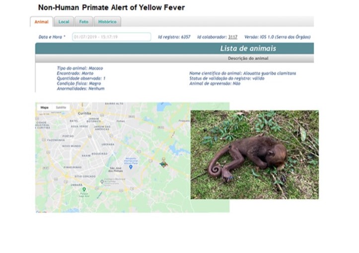 - © Municipality of São José dos Pinhais
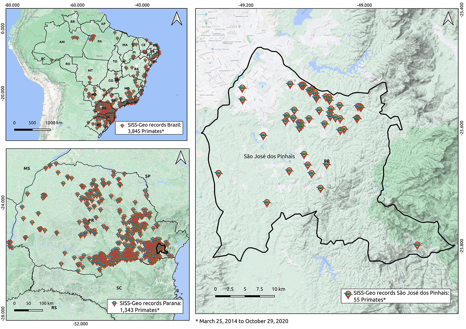 - © Municipality of São José dos Pinhais
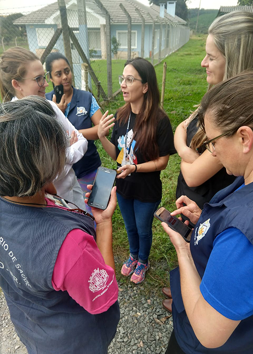 - © Municipality of São José dos Pinhais
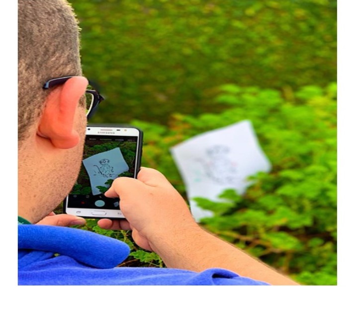 - © Municipality of São José dos Pinhais
Item 1 of 5
Status
completed
100%
City
São José dos Pinhais
Main actors
Local Government, Public Utility, Research Institutes / Universities
Project area
Whole City/Administrative Region
Duration
2018 - 2022
A collaborative technology platform that monitors wildlife health risks
Yellow fever* arrived in Brazil around 1600 and soon became endemic in the Amazon region. The virus irregularly disperses causing outbreaks, illness and death. Since 2017, Brazil has experienced the biggest outbreak in 80 years. The virus is transmitted by mosquitoes which are most likely present in wild areas. However human activities transform the environment and forest areas are urbanized, bringing risk to people. The dispersion of the virus to regions with low vaccination coverage necessitated the identification of priority areas for control and prevention. The Brazilian experience shows that non-human primates (NHP) die before people, which gives health authorities an alert of viral transmission. The municipality of São José dos Pinhais used the SISS-Geo Platform for monitoring NHPs, to generate strategic data for the identification of priority areas for vaccination, carried out 2 months in advance, saving millions of lives in the region.
* Yellow fever is a viral disease that is transmitted by mosquitoes. Yellow fever can lead to serious illness and in some cases death. It is called ‘yellow fever’ because in serious cases, the skin turns yellow in colour.
City
São José dos Pinhais, Brazil
Size and population development
Brazil's government statistics agency, IBGE, estimates the 2020 population of São José dos Pinhais is 329,059 which reflects an annual growth rate of 2.6% since the 2010 census. The city covers an area of 946.4 km2 with a population density of 350 people per km2.
Population composition
IBGE data from the 2010 census states the population is comprised of 50.9% females and 49.1% males. The 0-14 age group is recorded at 24.5%, 15-59 at 68.1% and 60+ at 7.4%. Of the total population 97.1% reside in the urban area of the municipality. The Roman Catholic religion is the most followed among citizens.
IBGE postponed the 2020 census due to the COVID 19 pandemic.
Main functions
São José dos Pinhais is the second largest city in the Greater Curitiba metropolitan region located in the state of Paraná in southern Brazil The city lies on a plateau 906 meters above sea level. The municipality contains 12.38% of the Guaratuba Environmental Protection Area (199,587 hectares), established in 1992 and 13.4% of the Guaricana National Park (49,287 hectares).
Main industries / business
São José dos Pinhais’s economy is based on services and trade. The main industries are tourism, chemicals, food, arts and culture. It is the third largest automobile hub in Brazil and manufactures the assembly of Volkswagen, Audi Nissan and Renault. The city is also home of the Afonso Pena International Airport, the main airport for southern Brazil.
Sources for city budget
To secure decentralisation, the 1988 Constitution allocated a substantial amount of taxes and compulsory transfers to state and municipal governments. Tax revenue and other own-source revenue (tariffs and fees, property income) represent 43% of Municipal government revenue while grants and subsidies from the Federal and Sub National governments account for 57%.
Political structure
The Brazilian Constitution determines which activities are to be performed or regulated exclusively by the federal level, and which are the responsibility of the municipalities. The municipalities are not a creation of the states and are not governed by them. They are granted the status of federal entities, at the same level as the states and are governed by an organic law, which must comply with federal and state constitutions. Municipalities are subdivided into districts which are deconcentrated municipal localities.
Administrative structure
The City Council is composed of 21 councillors who are elected by the residents every four years. The Council has four areas of action: legislative, supervisory, judicial and advisory.
The Board of Directors are elected every two years and members oversee executive and disciplinary functions of all legislative and administrative works of the City Council.
The Commissions are technical bodies comprised of members of the City Council and carry out studies and investigations, issue specialized opinions, and represent the Legislative Power. Commissions are permanent, special or representative.
Website
http://www.sjp.pr.gov.br
The Brazilian Wildlife Health information System, SISS-GEO uses zoonosis surveillance* strategies and policies which involve central, state and municipal collaboration.
Worldwide, the importance of biodiversity in the transmission of zoonoses has been studied. However, prevention and control options are limited and frequently dependent on vaccinating people, this mostly happens after outbreaks or epidemics and compromises lives. The goal of the municipality of São José dos Pinhais, a neighboring city in the state capital of Paraná, is to develop technology and participatory strategies that involve different sectors and levels of government and society to generate quality data to guide and establish public policies and actions to address the emergence of *zoonoses in Brazil.
*zoonosis surveillance is the ongoing systematic collection, analysis, interpretation and dissemination of information about the occurrence, distribution and determinants of diseases transmitted between humans and animals
*A zoonosis is any disease of infection that is naturally transmissible from vertebrate animals to humans. There are 200 know types of zoonoses.
SISS-Geo is developed using free software, with the collaboration of dozens of specialists from different knowledge fields and has been tested in traditional and indigenous communities in the Amazon and the Atlantic Forest. The system has become an auxiliary tool in the monitoring of epizootic diseases* where the information in the records serves as input for predictive models, making it possible to anticipate and recognize emergency situations in real time, allowing to activate the services responsible for prevention and control actions
*epizootic disease is a disease event in an animal population akin to an epidemic in humans. It generally refers to outbreaks of disease which cause serious economic or public health issues and are of major importance in the international trade of animals and animal products.
SISS-Geo stands out from most information systems for having citizen participation inherent in its development, not only in data entry, but also for its improvement. The open data is available for everyone, from citizens to researchers and decision makers. In addition to data collected through smartphones, the SISS-Geo platform integrates data from researchers and other databases. This large mass of data is worked through machine learning methods, producing computational models that indicate factors favouring the occurrence of zoonoses. The system works offline and includes, in addition to images, information about the observed animal, georeferencing accuracy, algorithms that identify abnormalities in the animal's physical conditions, generating alerts to the health system, recording environmental impacts at the observation site, in addition to providing a direct communication channel. The system also stores an audit of records and taxonomic validation of registered animals. Additionally, collected data is used to promote local education and health actions with communities, the production and distribution of newsletters and scientific materials that are easy to understand for people with minimal education.
SISS-Geo collects images of the animal, date, location, number of animals, whether alive, dead or sick, species information, physical conditions of the animal, age group, sex, local impacts (highways, agriculture, conservation unit, floods and others) and user information (profession, age, sex, interest ...). The data is entered in related to the Brazilian and international geospatial databases. The collection of dead animals and biological samples are correlated through registration in the National Information System for Notifiable Diseases (SINAN), which includes the final diagnosis that allows the identification of critical points for vaccination block, characteristics of the population at risk, need for support local actions by the state or general coordination and animal protection actions, when possible.
Automatic alerts sent in real time by an algorithm identify risk situations for yellow fever. This includes practical actions such as the placement of trained teams for the collection of animals in a quick time in order to guarantee a reliable laboratory diagnosis. It is worth mentioning that the yellow fever virus is an RNA virus that degrades quickly when the host dies. This fact makes the SISS-Geo alert a strategic tool.
After extensive distribution of information by the municipality's administration in the media and social networks, the population started to act as sentinel, reporting the cases of epizootic diseases, which enabled the São José dos Pinhais Zoonoses Surveillance Unit to cover the extensive area of the municipality to make the records, notifications, sample collection, immunoprophylaxis*, and identify critical points and anticipate the block in the possible areas of expected viral circulation.
* the prevention of disease by the production of active or passive immunity
This initiative was initially financed by the Global Environmental Fund (GEF) for the development of the Public-Private Initiative Program for Biodiversity, coordinated by the Ministry of the Environment, with the objective of mainstreaming conservation in the various sectors of the government. Today, it is maintained by FIOCRUZ, with support from the National Laboratory of Scientific Computing (LNCC) and the Ministry of Health.
Until 2017, The GEF resources financed the team of system developers and made it possible to test the SISS-Geo in remote communities in the Amazon and Atlantic Forest. From the beginning, Fiocruz assumed its maintenance with researchers. The National Laboratory for Scientific Computing (LNCC) meets the demands of heavier computational processing. The Ministry of Health promotes the development of specific tools and with the states and municipalities the integration and training. The society collaborates with records for health and conservation.
The use by health services in localities strengthens professionals, pointing out ways for data quality assurance and for forecasting actions. It provides empowerment and autonomy for men and women, adults and young people from different ethnic and cultural backgrounds, through the exchange of knowledge with professional health teams. With the SISS-Geo records and the participation of health teams and communities it was possible in the southern region of Brazil to vaccinate people against yellow fever 2 months before the virus circulated.
The platform integrates citizens with the public health service and its results save lives, promote public policies, well-being and. The system was designed to be technologically lightweight, to work on old smartphones and thereby give digital accessibility to all Brazilians.
In the recent outbreak of yellow fever, the identification of NHP has become crucial for identifying areas of circulation of the virus. Fiocruz, in partnership with the General Coordination of Arboviruses (Ministry of Health) and the State Health Secretariats, had already been working to ensure that the SISS-Geo was adopted by health agents and communities who are in the field with this mission. When the yellow fever spread to the southern states of Brazil, we started to receive hundreds of NHP records from Paraná State. The training sessions, where the SISS-Geo was presented to managers, was made available to professionals in the field started to use it voluntarily. From then on, training was intensified for several municipalities and we created exclusive information flows with alerts for the health and environmental sector of the states. The records were used to feed the methodology of the dispersion corridors, which allowed the identification of priority areas for vaccination and the time that the virus would take to reach the municipalities. In this way, the entire health team of São José dos Pinhais got involved and registered dead animals, adding quality of information and action that resulted in the period from July 2019 to June 2020 no death in 123 zoonoses cases in the state.
The use of SISS-Geo technology, recognized by the Official Brasil SDGs 2018 Award, minimizes national challenges faced by its territorial dimensions, limited resources and socio-environmental differences. Therefore, it allows actions to improve the quality of life, the conservation of species, among other benefits that contribute to the SDGs and the National Biodiversity Action Plan and Strategies.
The speed of identification of a dead or sick animal, its exact location, and the conditions in which dead and sick animals are found is fundamental for the proper collection of the animal and the collection of biological samples that can be analyzed in the laboratory. All of these logistics are based on the first information of a citizen who finds the animal in the wild, in urban or rural areas. However, the flow of this information is generally slow and without the most important information. The risk of these illnesses arising in nearby distant or even urban areas can put millions of people and species at risk. The SISS-Geo Platform allows photographing, providing information and geo-referencing animals. This information is distributed in real time so that actions are taken.
The formal incorporation of SISS-Geo as a tool used by municipalities and states throughout Brazil, will promote its importance due to its ease of use and quick and safe solutions for decision makers. The search for complementary financing aims to ensure innovation and expand users.
The training that introduced the SISS-Geo to the Municipality triggered several simple actions, such as educational work on yellow fever, the importance of its immunoprophylaxis, as well as the epizootics of non-human primates in areas at risk prior to the introduction of the virus in the region. With the reduced staff and other demands of the unit, it would be impossible to actively search for primates in the large territory.
In 2019 we started to receive several warnings from the population regarding epizootics and then we were able to use the system that allowed us to understand which were the most critical areas for more incisive punctual actions, resulting in only 1 autochthonous case of the disease. These actions have already involved, in addition to São José dos Pinhais, hundreds of municipalities in Brazil. The experience was shared with several cities in a lecture promoted by the Union of Veterinary Doctors of Paraná and should be transmitted to as many cities as possible to obtain optimal results, in a timely manner and with a preventive character.
It is crucial to convince decision makers and researchers of the following:
- anyone can use an app to monitor wildlife health;
- that the Platform should be developed in-house by a multidisciplinary team;
- that all the effort would only be worth it if the system was incorporated by the national health and environmental services;
- multi and interdisciplinary team; application and testing of the platform "in situ";
- users participation through direct lines, on social networks and in workshops and training sessions.
Winner of Medal of Honor at the 5th Guangzhou Award: http://www.guangzhouaward.org/a/1364
On Map
The Map will be displayed after accepting cookie policy
Want to know more about this project?

Photo gallery


