Revitalization of Namur-De la Savane area

Status
ongoing
50%
City

Montréal

Main actors

City Government, Private Sector

Project area

Neighborhood or district

Duration

Ongoing since 2014

Addressing urban sprawl by sustainable transformation of vacant land.

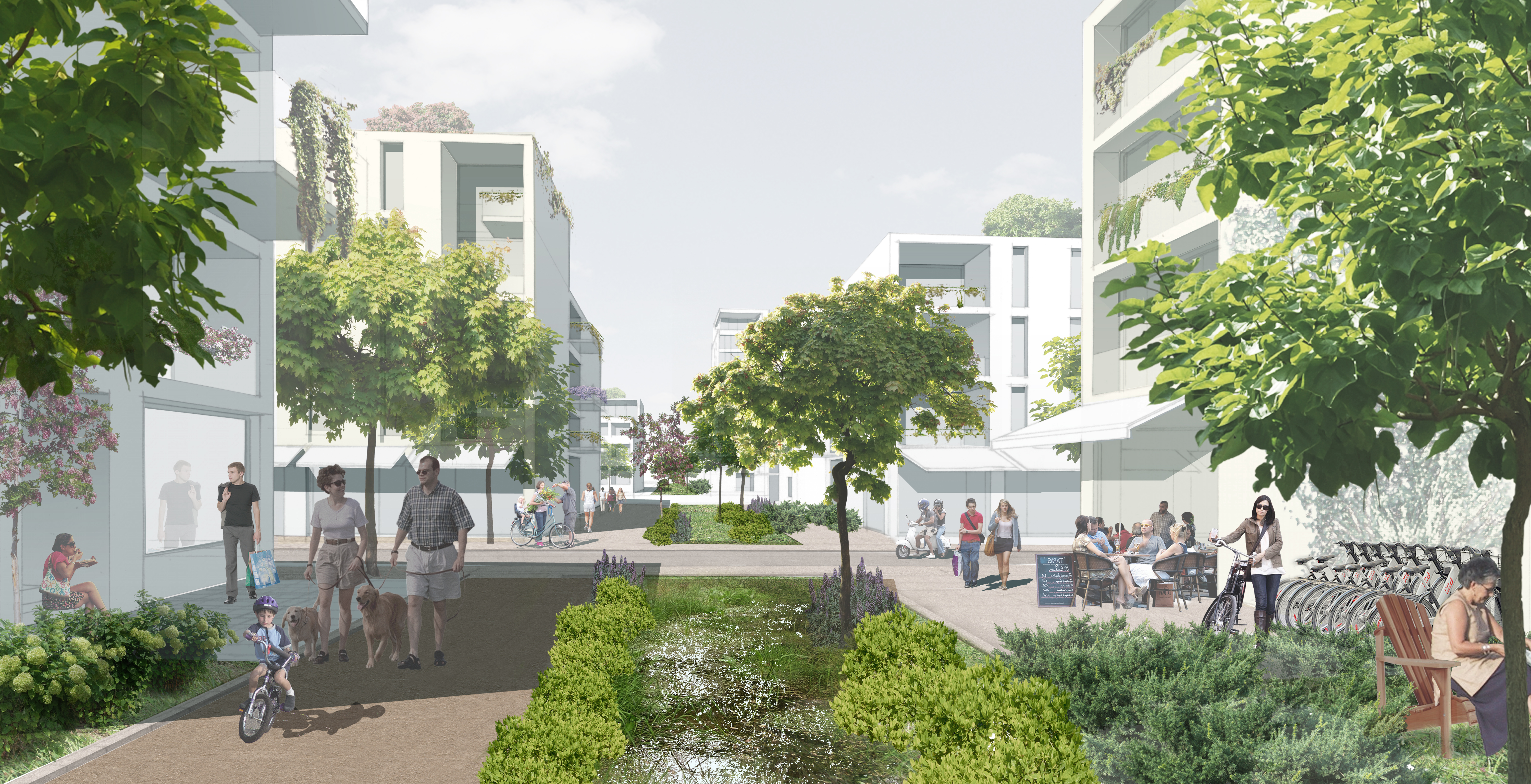
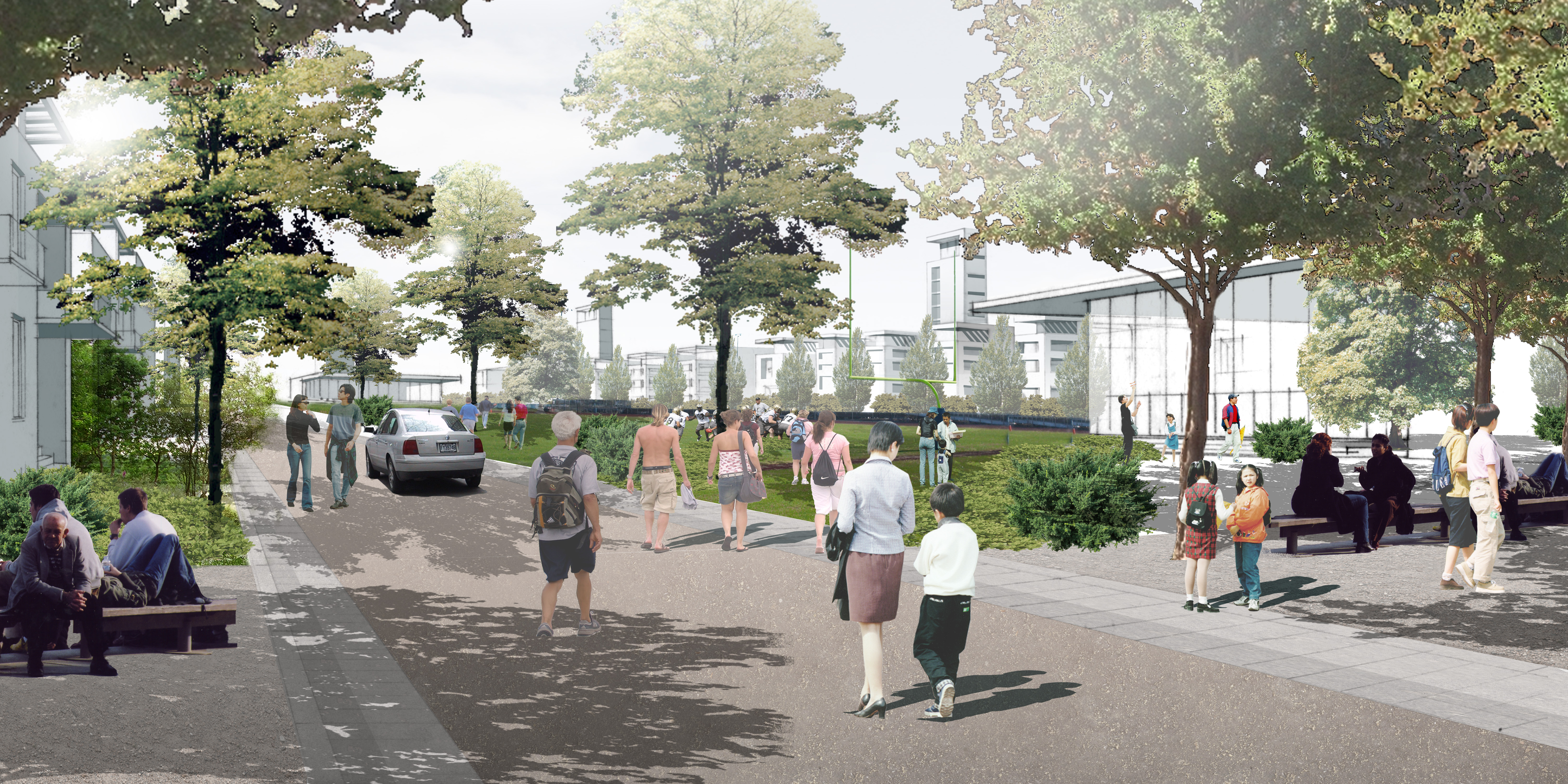
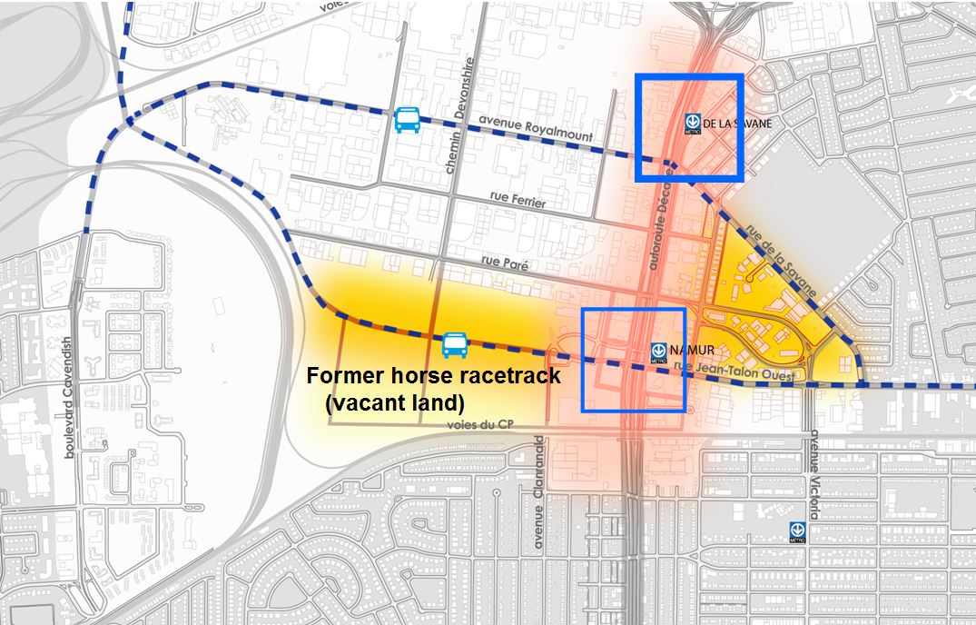
The Namur-De la Savane is a vast area located in the heart of Montréal, at the crossroads of two major highways and linking downtown with the western economic centre of the city. Two metro stations link the area to the down town. Owned by the municipality since 2017, a former racecourse site, which is an important component of  the area, will be transformed into a new neighbourhood. The site is one of the last major vacant sites on the island of Montréal (43 hectares). The city government aims to revitalize and develop the site to accommodate nearly 5,000 housing units, built to high standards of sustainable development. Main access to the area is on the east side, where a complete reconfiguration of the urban space around Namur metro station is planned. The establishment of new transport connections will improve accessibility to the area, reducing its isolation and opening it up to the city.

This project has been chosen by the city of Montreal to be peer-reviewed in the frame of the Sustainable Cities Collaboratory: https://use.metropolis.org/news/sustainable-cities-collaboratory

Sustainable Development Goals

Build resilient infrastructure, promote inclusive and sustainable industrialization and foster innovationMake cities and human settlements inclusive, safe, resilient and sustainable
City
Montréal, Canada
Size and population development
Montréal is the most populous city in the province of Quebec, with an approximate population of 2 million people as of 2017. Greater Montréal has more than 4 million people; with 2 million males and 2.09 million females. The 2030 population for Greater Montréal is forecast to reach 5.2 million people.
Population composition
2.2 million people in Montréal speak both French and English. 60,000 people in the Metropolitan area do not speak either of the official languages. These people speak Aboriginal languages like Inuit and Cree-montaignais, but also non-Aboriginal languages such as Afroasiatic ones (e.g. Creole, Yiddish) and Indo-European (e.g. Slavic variations, German). Minority populations comprise together over half a million inhabitants in the Metropolitan area of Montréal, and natives have been registered as approximately 42,000 people.
Main functions
Montréal is the most populous municipality in the Canadian province of Quebec and the second most populous municipality in Canada. The city is located in the southwest of Quebec and covers most of the Island of Montreal at the confluence of the Saint Lawrence and Ottawa Rivers. French is the city’s official language and is the language spoken at home by 49.8% of the city’s population, it is the second largest primarily French speaking city in the world, following Paris. Named after the three peak mount that stands in the middle of the city—“Mount Royal”—a site formally occupied by an indigenous village called Hochelaga. After the conquest, a French fur trading post grew into a city across the 1600s. Today, Montréal is a major tourist city and is recognised as a hub for technology research and development and the creative industries.
Main industries / business
After Toronto, Montréal is the biggest economy in Canada. The city of Montréal identifies as its principal and developing industries the following: aerospace, food, cinema and television, finance, fashion and clothing, life sciences (research and innovation), information technologies, transport and logistics. Certainly, Montréal excels in the area of aeronautics and technology development, as many of the world’s cutting-edge companies have set their headquarters there. Among the more famous companies installed in the city include the World Anti-Doping Agency, the Canadian Space Agency, the production company Alliance Films, and the videogame company Ubisoft. It has also gathered the attention of artificial intelligence developers, such as Facebook AI Research, Microsoft Research, Google Brain, DeepMind, etc. The Port of Montréal, another of Quebec’s economic features, located inland, transacts 26 million tonnes every year. Montréal is also considered a key cultural capital. It has strong film, television and theatre industries, with for example Cirque du Soleil being headquartered in this city. Also, its music scene has impacted worldwide through festivals such as the Montréal International Jazz Festival, the largest in the world. Another feature of Montréal is its ice hockey scene, with the local team “Montréal Canadiens” as a central participant of the NHL.
Sources for city budget
The budget of the city is elaborated by the mairesse and her executive committee for approval by the rest of the municipal council. It must include expenditure that relates to public security, subvention programmes for real estate and urbanization projects, the environment, and a three-year government plan.
Political structure
The government of Montréal is led by a mayor, the councils of the boroughs and the city council, with the municipal council being made up of 65 elected officials. The mayor, Valérie Plante, is the first woman to occupy the role since the founding of the city, and she is equal to the other 64 members of the council. In political matters, the mayor stands as the head of the executive committee, which she nominates, and is in charge of deciding local competencies, services relevant to the urban agglomeration of the île de Montréal (the island that comprehends the city as well as the surrounding suburbs), and the generation of documents that relate to the city budget and its rules. The opposition party (the second runner-up) has an active role of watchdog functions and freedom of expression regarding the decisions taken by the mayor.
Administrative structure
The municipal council is also in charge of the budget of Montréal. This includes the urban agglomeration of the île de Montréal: that is, its 19 arrondisements or boroughs and 15 banlieues or suburban areas. Each of the boroughs has a mayor, elected by the local citizens. They and the councils of the boroughs are tasked with matters regarding local urbanism, culture, parks and recreation, community development, human resources, housing, etc.
Website
http://www.ville.montreal.qc.ca
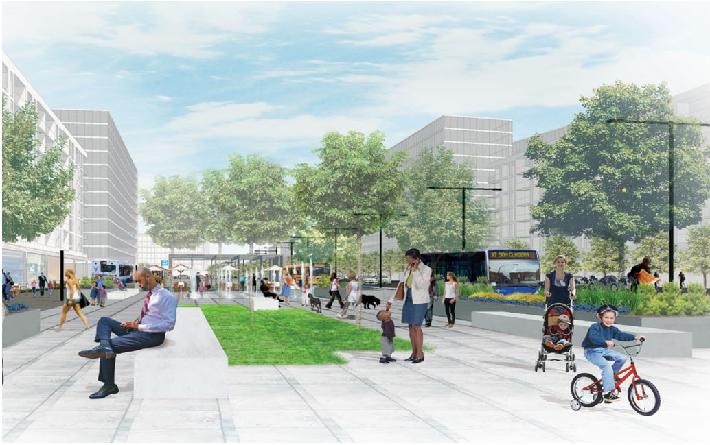
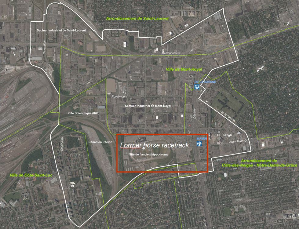
Considering the critical mobility issues, the city government has expanded the site’s planning scale to include the whole Namur-De la Savane area. This planning approach makes it possible to have a better territorial coherence.

Due to its location, the area enjoys considerable economic vitality. Several large employers are located there with the number of specialized businesses increasing. However, due to the physical barriers that divide the territory, much of its potential remains untapped and this hinders diversification of economic activity.

The presence of two metro stations that offer a direct and fast link to the city centre should be a significant asset to the area. However, after nearly 30 years of operation this has not significantly increased the use of public transport in the area. Moreover, despite the importance given to car traffic in the area, circulation is also difficult. Highways and service roads generate a large number of vehicles that converge in the area and congest portions of the local road network, particularly during peak hours. Given this context, the transformation of the area depends on the implementation of a public transit service with better accessibility to the existing metro stations.

Characterized by a shortage of parks and green spaces, the absence of natural environments and the widespread use of dark and impermeable materials, the area itself is a vast heat island. However, it has the potential for greening both on public and private properties.

Considering all these findings, the transformation of the former racecourse site into a new neighbourhood will be based on the following objectives.

Objectives

  • Transforming a large vacant site into a  new neighbourhood.
  • Improving travel conditions to enable the area to reach its full potential.
  • Financing of interventions, particularly in the area of travel.
  • Enhancing the image of the area by defining a new identity.
  • Raising community expectations for family, social and community housing.

Since February 2014, the City of Montréal’s centre of area development (Service de la mise en valeur du territoire de la Ville de Montréal), in collaboration with representatives of the municipality and borough departments have been collaborating to develop a planning process for the Namur - De la Savane area.

The main streams of research include:

  • Diagnosis of the territory
  • Noise and vibration
  • Partial covering of the Décarie Autoroute
  • Financial analysis
  • Transportation needs and travel solutions
  • Functional and landscape characterization of public places

The city government aims to integrate the issues associated with the various territorial components in order to establish a coherent development and planning concept in terms of employment, urban form and mobility. To do this, particular attention is paid to the two sub-sectors that the planning process identified as priority areas for intervention:

  1. The redevelopment of the surroundings of the Decarie axis is a prerequisite for improving the quality of life in the adjacent neighbourhoods. Objectives are to increase urban activities and to improve travel conditions, with priority given to public and active transport that will serve existing neighbourhoods and new projects. In particular, it will be essential to make the Namur metro station and its surroundings the hub and link between the neighbourhoods on either side of the Décarie autoroute, for all modes of transportation.
  2. The grounds of the former Montreal Racecourse are one of the last major vacant sites on the island. Integrated into the planning of the Namur-De la Savane sector, a development concept for the site and its surroundings is accompanied by a series of challenges, particularly with regard to the isolation of the land, the safety of the site and the proximity of nuisance-generating activities.

 Development hypotheses are being studied based on the following principles:

  • densify and diversify urban activities around metro stations and public transit corridors;
  • multiply the links and increase the quality of the development;
  • revitalize the development of the public domain and increase greening;
  • connect the “Triangle” area with the site of the former Montreal racetrack while integrating the metro station;
  • reduce the ecological footprint of the planned area.

These development hypotheses made it possible to identify the main municipal interventions required to support the revitalization of the area. These are also studied on the basis of their technical and financial feasibility.

The main interventions relate to the following goals:

1. The improvement of travel conditions:

  • The Cavendish project, which meets a current need to complete the road network in this part of the agglomeration, will also provide access to the area from the west, particularly by public transit.
  • The addition of new links in the vicinity of Namur, which will contribute to offering, in addition to the Cavendish project, better accessibility to the site of the former racecourse and better access to the metro station, particularly for pedestrians.

2. The quality of public domain development:

  • Municipal interventions will be required to enhance the overall image of the neighbourhood. These interventions will focus on pedestrian comfort, safety and the revitalization of the site of the former racecourse.
  • Interventions prior to the revitalization of the site, such as street access, underground infrastructure and even certain community facilities, will be required.

Planification du Secteur Namur-De-la Savane, Diagnostic, Service de la mise en valeur du territoire, Montreal, Novembre 2014

RECHERCHE DOCUMENTAIRE PRÉALABLE À L’ÉVALUATION PATRIMONIALE DU SITE DE L’ANCIEN HIPPODROME DE MONTRÉAL

On Map

The Map will be displayed after accepting cookie policy

Want to know more about this project?

Sustainable Cities Collaboratory
Berlin, Germany

Sustainable Cities Collaboratory

Institution | Network
Sustainable Cities Collaboratory
Berlin, Germany

Sustainable Cities Collaboratory

Institution | Network
Karim Charef
Greater Montreal, Canada

Karim Charef

Individual | Urban planner, Architect.

Photo gallery

Related case studies

Recycling Initiative of Karak municipality, Jordan
Karak, Jordan

Recycling Initiative of Karak municipality, Jordan

A small project in Karak is making a significant shift towards more sustainable waste management in Jordan.
Estidama Sustainability Program
Abu Dhabi, United Arab Emirates

Estidama Sustainability Program

In one of the world’s most rapidly growing cities, a new government-mandated program – Estidama (Arabic for “sustainable”) - aims at making all new buildings in the United Arab Emirates more environmentally responsible and sustainable.
4°C Cooler – Using green infrastructure to build a climate resilient Melbourne
Melbourne , Australia

4°C Cooler – Using green infrastructure to build a climate resilient Melbourne

In 2010 the city of Melbourne appointed a new Urban Landscape Team to produce a Green Infrastructure Program to cope with a difficult future climate and maintain its economic prosperity and liveability.